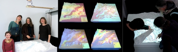
Adds three-dimensionality in modeling the effects of climate change
The Living Map adds three-dimensionality to the projections often used in modeling the effects of climate change. Historical, present, and future geological projections provide important data for resiliency planning regarding coastal sea level inundation. The digital map layers are from Surging Seas, the Dunedin City Council, the Otago Regional Council, and the National Library. This project was led by Bridie Lonie from the Dunedin School of Art along with Sara Dean and Beth Ferguson from the ZERO1 New Zealand Arts Incubator with the help of Luke Easterbrook from the University of Otago, the Otago Museum, and Workspace and Andrew Early at Otago Polytechnic.
Community Project Members:
-
Bridie Lonie
-
Luke Easterbrook
-
Beth Ferguson
-
Sara Dean
-
Andrew Early